Overview
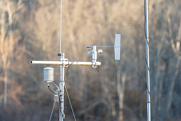
A Remote-Sensing / Earth-Observation Scientist is a specialized professional who uses satellite imagery, aerial data, and advanced technologies to monitor and analyze the Earth's surface, atmosphere, and oceans, contributing to insights in environmental management, disaster response, and climate studies. They work in diverse environments including research institutions, government agencies, universities, and private geospatial companies. Remote-Sensing Scientists apply expertise in geospatial analysis, data processing, and sensor technology to investigate natural and human-induced changes, model environmental trends, and support policy for sustainable development, driving advancements in resource management and global monitoring. Combining knowledge of geophysics, computer science, and environmental science, they play a crucial role in shaping evidence-based solutions in a world increasingly reliant on accurate Earth data for decision-making.
Remote-Sensing / Earth-Observation Scientists are experts who focus on collecting and interpreting data from remote-sensing platforms to understand Earth's systems, identify environmental changes, and develop strategies for addressing challenges like deforestation, urbanization, and natural disasters, applying their findings to tackle issues in conservation, agriculture, and public safety. Their work involves processing satellite and aerial imagery, creating geospatial models, and collaborating with interdisciplinary teams to translate data into actionable solutions. They often operate in academic, governmental, or commercial settings, balancing rigorous scientific investigation with real-world impact. Remote-Sensing Scientists are essential to fields like climate monitoring, disaster management, and land-use planning, serving as key contributors to science-driven solutions for environmental challenges, advancing sustainable practices, and ensuring planetary health. They tackle critical issues through methodical research and improve outcomes through evidence-based strategies in a landscape where Earth observation remains vital due to its widespread environmental and societal impacts.
Roles and Responsibilities
💼
Remote-Sensing or Earth-Observation Scientist
Roles and Responsibilities
Data Collection and Processing
Acquire and process data from satellites, drones, and ground-based sensors to monitor Earth's features.
Apply image correction techniques to account for atmospheric distortions and sensor errors.
Environmental Monitoring
Analyze changes in land cover, vegetation health, and water bodies using remote-sensing data.
Assess impacts of climate change, deforestation, and urbanization on ecosystems.
Disaster Assessment and Response
Map disaster-affected areas to support emergency response for floods, earthquakes, and wildfires.
Provide real-time data for disaster risk reduction and recovery planning.
Reporting and Communication
Prepare scientific reports, maps, and presentations to share findings with researchers and policymakers.
Communicate complex geospatial data to the public, government officials, and stakeholders.
Policy and Advisory Support
Collaborate with governments and organizations to develop environmental management strategies.
Provide data-driven input for policies on land use, conservation, and climate adaptation.
Field Validation and Calibration
Conduct ground-truthing to validate remote-sensing data with on-site observations.
Calibrate sensors and models to ensure accuracy of collected data.
Consulting and Advocacy
Advise industries, urban planners, and NGOs on sustainable land and resource management.
Advocate for the use of Earth observation data in addressing global environmental issues.
Research and Development
Innovate new methods for data acquisition, processing, and interpretation in remote sensing.
Contribute to academic publications or policy advancements in Earth observation.
Technology Integration
Use geospatial tools like GIS and machine learning to analyze and visualize Earth data.
Leverage cloud computing for large-scale data storage and processing.
Interdisciplinary Collaboration
Work with climatologists, ecologists, and engineers to integrate remote-sensing data into broader sustainability initiatives.
Partner with global organizations for coordinated efforts in Earth monitoring and research.
Roles and Responsibilities:
- Data Collection and Processing
- Acquire and process data from satellites, drones, and ground-based sensors to monitor Earth's features.
- Apply image correction techniques to account for atmospheric distortions and sensor errors.
- Environmental Monitoring
- Analyze changes in land cover, vegetation health, and water bodies using remote-sensing data.
- Assess impacts of climate change, deforestation, and urbanization on ecosystems.
- Disaster Assessment and Response
- Map disaster-affected areas to support emergency response for floods, earthquakes, and wildfires.
- Provide real-time data for disaster risk reduction and recovery planning.
- Reporting and Communication
- Prepare scientific reports, maps, and presentations to share findings with researchers and policymakers.
- Communicate complex geospatial data to the public, government officials, and stakeholders.
- Policy and Advisory Support
- Collaborate with governments and organizations to develop environmental management strategies.
- Provide data-driven input for policies on land use, conservation, and climate adaptation.
- Field Validation and Calibration
- Conduct ground-truthing to validate remote-sensing data with on-site observations.
- Calibrate sensors and models to ensure accuracy of collected data.
- Consulting and Advocacy
- Advise industries, urban planners, and NGOs on sustainable land and resource management.
- Advocate for the use of Earth observation data in addressing global environmental issues.
- Research and Development
- Innovate new methods for data acquisition, processing, and interpretation in remote sensing.
- Contribute to academic publications or policy advancements in Earth observation.
- Technology Integration
- Use geospatial tools like GIS and machine learning to analyze and visualize Earth data.
- Leverage cloud computing for large-scale data storage and processing.
- Interdisciplinary Collaboration
- Work with climatologists, ecologists, and engineers to integrate remote-sensing data into broader sustainability initiatives.
- Partner with global organizations for coordinated efforts in Earth monitoring and research.
Study Route & Eligibility Criteria
Study Route & Eligibility Criteria
Remote-Sensing or Earth-Observation Scientist
Route 1
🎓
1
10+2 with Physics, Chemistry, and Mathematics as core subjects.
🏛️
2
Bachelor's degree in Geography, Environmental Science, or Earth Sciences .
3-4 years
🏛️
3
Master's degree in Remote Sensing, Geoinformatics, or Geomatics .
2 years
💼
4
PhD in Remote Sensing or Earth Observation .
💼
5
Postdoctoral research or industry experience in geospatial studies .
Route 2
🎓
1
10+2 with Physics and Mathematics.
🏛️
2
Bachelor's degree in Physics, Geology, or Computer Science .
3-4 years
🏛️
3
Master's degree in Geospatial Science or Earth Observation .
2 years
💼
4
Specialized training in remote-sensing software .
💼
5
Practical experience in geospatial labs or internships.
Route 3
🎓
1
10+2 with Physics and Chemistry.
🏛️
2
Bachelor's degree in Engineering or Information Technology .
4 years
🏛️
3
Master's degree in Geoinformatics or Environmental Engineering .
2 years
💼
4
Certification or short-term training in remote sensing and GIS .
💼
5
Industry experience in environmental or geospatial sectors.
Route 4
🎓
1
10+2 with Physics and Mathematics.
🏛️
2
Bachelor's degree from India in relevant field .
3-4 years
🎓
3
Master's or PhD in Remote Sensing or Earth Observation abroad .
2-5 years
📚
4
Training or postdoctoral research in international geospatial programs .
1-3 years
💼
5
Certification or licensure for international practice .
🎯
Remote-Sensing or Earth-Observation Scientist - Professional
Significant Observations (Academic Related Points)
💡
Remote-Sensing or Earth-Observation Scientist
Academic Related Points
1
Competitive Entrance Examinations:
Clearing university-specific entrance tests for Bachelor's and Master's programs or national-level exams for research fellowships in India and abroad is critical for entry into relevant programs.
2
Variable Academic Commitment:
Requires a journey of 5-10 years post-high school for most roles, with additional years for PhD or postdoctoral research in Remote Sensing.
3
Strong Foundation in Core Subjects:
Academic excellence in subjects like Physics, Mathematics, and Geography during undergraduate studies is essential for understanding geospatial technologies.
4
Practical Performance:
Hands-on training during Master's or PhD programs in remote-sensing tools and GIS is crucial for securing competitive positions in Earth Observation.
5
Research and Publications:
Engaging in geospatial research projects and publishing findings during academic or professional programs can enhance prospects for academic and policy roles.
6
Fellowship Selection:
Securing research fellowships or grants often requires a strong academic record, analytical skills, and relevant project experience in remote-sensing studies.
7
Continuous Education:
Mandatory participation in workshops, seminars, and short courses to stay updated with evolving remote-sensing technologies and data analysis methods.
8
Specialization Certification:
Obtaining certifications in niche areas like satellite data processing or geospatial AI can provide a competitive edge in the field.
9
Subspecialty Training:
Pursuing additional training in areas like disaster mapping or climate monitoring can enhance career prospects.
10
Language Proficiency for International Practice:
Clearing language proficiency tests like IELTS or TOEFL with high scores is often necessary for pursuing opportunities abroad.
Internships & Practical Exposure
💼
Remote-Sensing or Earth-Observation Scientist
Internships & Practical Experience
1
Internships in geospatial labs focusing on satellite data processing and analysis.
2
Research apprenticeships with academic or governmental teams for applied Earth observation projects.
3
Observerships in meteorological or environmental agencies studying land and atmospheric patterns.
4
Participation in disaster mapping projects analyzing real-time crisis data.
5
Training in remote-sensing tools like ENVI and ArcGIS under supervision.
6
Experience in field units conducting ground-truthing for data validation.
7
Involvement in policy studies for environmental monitoring and resource management.
8
Attendance at geospatial or remote-sensing conferences and workshops.
9
Exposure to interdisciplinary projects with ecologists and urban planners.
10
Collaborative research in international Earth observation labs for global exposure.
Courses & Specializations to Enter the Field
📚
Remote-Sensing or Earth-Observation Scientist
Courses & Specializations
📖
Bachelor’s in Geography, Environmental Science, or Earth Sciences.
📖
Bachelor’s in Physics, Geology, or Computer Science.
📖
Master’s in Remote Sensing, Geoinformatics, or Geomatics.
📖
PhD in Remote Sensing or Earth Observation.
📖
Certification courses in Satellite Data Analysis and GIS.
📖
Training in Disaster Mapping and Environmental Monitoring.
📖
Specialized courses in Geospatial AI and Machine Learning.
📖
Master’s in Environmental Engineering with Remote Sensing focus.
📖
Continuing Education courses in Emerging Geospatial Technologies.
📖
Short-term courses in Hyperspectral Imaging Techniques.
Prominent Employers
🏢
Remote-Sensing or Earth-Observation Scientist
🌟 Top Companies & Organizations
🇮🇳 India
🏛️
Indian Space Research Organisation (ISRO)
🏛️
National Remote Sensing Centre (NRSC), Hyderabad
🏛️
Indian Institute of Remote Sensing (IIRS), Dehradun
🏛️
Ministry of Environment, Forest and Climate Change (MoEFCC)
🏛️
Indian Meteorological Department (IMD)
🏛️
Centre for Development of Advanced Computing (C-DAC)
🏛️
National Centre for Earth Science Studies (NCESS)
🏛️
Wildlife Institute of India (WII), Dehradun
🏛️
Ashoka Trust for Research in Ecology and the Environment (ATREE)
🏛️
The Energy and Resources Institute (TERI), New Delhi
🌍 International
🌐
National Aeronautics and Space Administration (NASA), USA
🌐
European Space Agency (ESA), Europe
🌐
National Oceanic and Atmospheric Administration (NOAA), USA
🌐
United Nations Environment Programme (UNEP), Global
🌐
World Resources Institute (WRI), USA
🌐
Maxar Technologies, USA
🌐
Planet Labs, USA
🌐
Airbus Defence and Space, Europe
🌐
Google Earth Engine, Global
🌐
Environmental Systems Research Institute (ESRI), USA
Advice for Aspiring Remote-Sensing or Earth-Observation Scientists
💡
Remote-Sensing or Earth-Observation Scientist
🌟 Tips for Students & Parents
1
Build a strong foundation in environmental science, physics, and mathematics during undergraduate studies to prepare for specialized learning.
2
Seek early exposure through internships or field projects to gain practical experience in geospatial analysis techniques.
3
Develop technical skills in remote-sensing tools like ENVI and GIS during Master's or PhD programs for a competitive edge.
4
Engage in interdisciplinary learning by exploring atmospheric science, ecology, and data science alongside remote sensing.
5
Pursue research opportunities or fellowships to deepen expertise in niche areas like disaster mapping or climate monitoring.
6
Cultivate mentoring relationships with established remote-sensing scientists for career guidance and networking opportunities.
7
Stay updated with advancements in satellite technology, AI integration, and international environmental policies.
8
Publish research findings or geospatial studies in scientific journals to establish credibility and contribute to the field.
9
Consider international exposure through collaborative projects, conferences, or advanced research abroad to broaden perspectives.
10
Balance technical expertise with communication skills to present complex geospatial data to non-scientific stakeholders effectively.
🎓 Final Message
A career as a Remote-Sensing / Earth-Observation Scientist offers a unique opportunity to impact global sustainability, scientific discovery, and societal well-being by leveraging advanced technologies to monitor and understand the Earth's dynamic systems. From tracking climate change to supporting disaster response, Remote-Sensing Scientists play a pivotal role in addressing some of the world's most pressing environmental challenges. This field combines rigorous scientific inquiry, interdisciplinary collaboration, and technological innovation, offering diverse paths in research, policy development, and applied geospatial solutions. For those passionate about environmental science, problem-solving, and improving planetary health, a career as a Remote-Sensing / Earth-Observation Scientist provides a deeply rewarding journey with significant potential for making meaningful contributions to society in an era where Earth observation continues to shape environmental strategies, policy innovations, and global responses across all sectors.